In our lives, we will use positioning in many places. When we do not know the geographical location of the location, we don’t know the direction of the road, etc., we will enable devices with navigation capabilities to locate and navigate; today, people rely heavily on positioning navigation devices and software. It can be said that it cannot be lacking. With the continuous improvement of smart phone functions, more and more users use mobile phone positioning systems for positioning navigation. In the actual use of mobile phone map positioning process, we will find that the actual location is inconsistent with the location displayed on the map. This we should have a deep understanding . So why is there always a deviation in mobile map location? Today, let's talk about this topic.

First of all, let's first understand the mobile phone positioning method. The current mainstream mobile phone positioning methods can be divided into three categories: GPS positioning, base station positioning, and hybrid positioning.
GPS positioning is to get the position information through the GPS module in the mobile phone, the accuracy is relatively high and the information is comprehensive; not only can obtain latitude and longitude, but also can include information such as altitude and direction angle.
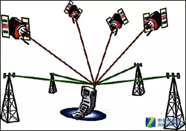
Mobile phone positioning through GPS
The base station positioning is based on the carrier's telecom base station for positioning. Since it does not involve hardware consumption, the power consumption is the lowest. The algorithm and the base station data can obtain ideal positioning accuracy. However, the base station positioning accuracy requires a high degree of base station distribution. Dense regional positioning accuracy is high, and the decentralized base station positioning accuracy will decline.
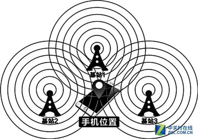
Mobile phone positioning through the base station
Hybrid positioning is to confirm the location of the user by integrating the base station and WiFi data. This method combines the low power consumption of the base station positioning, and improves the accuracy of the positioning of the base station due to the intervention of WiFi data, but the service provider and the WiFi data, the base station The data requirements are high.
Now, the maps on the mobile phone use GPS positioning, base station positioning and hybrid positioning for positioning navigation. The accuracy of base station positioning and hybrid positioning is affected by the density of base stations and the data provided by WiFi, although hybrid positioning can cover most of the applications. Scenes, but some uncertainties affect the accuracy of positioning. For example, temporary mobile base stations required by some large-scale activities will affect the accuracy of base station positioning. In addition, if the position of the router changes and the location in the WiFi database is not updated in time, it is very likely that WiFi positioning errors will occur. Some netizens here may ask: Is there GPS positioning, is GPS positioning not accurate?

There is a deviation in mobile GPS positioning
It is understood that in open areas (plains), GPS positioning accuracy is high, GPS positioning accuracy in indoor areas and urban buildings in dense areas will be biased, which is what we call drift; then we understand how GPS is based on satellite signals to achieve Positioning, GPS includes three parts: space GPS satellite constellation, ground monitoring system, user GPS signal receiver.
The basic principle of GPS positioning is that the satellite constantly emits its own ephemeris parameters and time information. After the GPS signal receiver receives the signal, the position of the receiver can be calculated according to the trigonometric formula. Three satellites can be positioned in 2D (latitude and longitude). ), four satellites can be 3D positioning (longitude, latitude and height). With the receiver constantly updating the received information, the direction and speed of the movement can be calculated.
After simply understanding the GPS positioning principle, in addition to the influence of the location of the base station and the location of the router, we analyze what causes the deviation in the positioning of the mobile phone map.
External factors:

The mobile map is affected by the environment when using GPS positioning
1. Atmospheric influence
The ionosphere and troposphere in the atmosphere will play a role in delaying the GPS signals. The refraction effect of the ionosphere on the electromagnetic waves will change the propagation speed of the GPS signals, and the troposphere will also have a refraction effect on the electromagnetic waves, thus affecting the propagation speed of GPS signals.
2. Satellite ephemeris error
The satellite ephemeris is determined by the ground monitoring station tracking satellites. Due to the complex influence of various kinds of perturbation forces during satellite operation, it is difficult to measure these forces sufficiently or reliably by the ground monitoring stations, so that large errors may occur in the ephemeris forecasting. It not only seriously affects the accuracy of single point positioning, but also is an important source of error for precise relative positioning.
3. Satellite clock error
The satellite clock error is the difference between the GPS satellite clock and the GPS standard time. In order to ensure the accuracy of the clock, GPS satellites are all using high-precision atomic clocks, but the deviations from GPS standard time and the total amount of drift and drift are still within 1ms to 0.1ms. The resulting equivalent error will reach 300km to 30km. . This is a systematic error that must be added to the correction.
4. Multipath effect
Due to the influence of the surrounding environment of the receiving terminal, the multipath effect causes the satellite signals received by the receiver to include the influence of reflection and refraction signals. This is also a factor that affects the positioning deviation in indoor and urban areas where buildings are dense.
Internal factors:
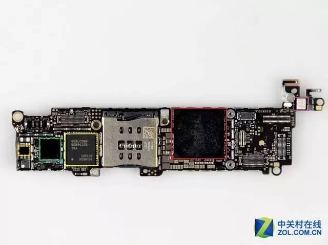
There is a deviation in mobile positioning and GPS chip
The internal factors here refer to the factors affecting the positioning of the GPS chip on the mobile phone's motherboard. Now the mainstream smart phones integrate the GPS chip technology into the CPU or baseband chip, but there are more than one manufacturer that provides the CPU or baseband chip. As a result, the performance of the product will inevitably be different, which is also a factor that causes GPS positioning deviation.
Map factor:

Map offset
It is reported that the values ​​of ordinary GPS positioning are based on the WSG-84 coordinate system standard, which is the world's common coordinate system. China's map standard coordinate system is GCJ-02, and the coordinate system conversion algorithm between GCJ-02 and WSG-84 is confidential.
This security plug-in is also called encryption plug-in or plus or partial or SM module. In fact, it is the artificial biasing of the real coordinate system. According to the algorithm of a few lines of code, the real coordinates are encrypted into false coordinates. It is not a linear bias, so the offset will be different everywhere. The encrypted coordinates are often referred to as the Mars coordinate system. After the conversion, there will be different degrees of deviation, which may also be one of the reasons for the mobile map positioning deviation.
Write last
In fact, mobile phone map positioning is not a single cause of the mobile phone itself, caused by many factors outside the influence of mobile phone map positioning accuracy, so we use mobile phone map positioning, try to avoid the impact of human factors, combined with real-time The use of the environment makes it possible to assist our lives to the greatest extent possible and to bring convenience to life.